


The aim of Street Orienteering is to collect as many points as you can in 45 minutes by running/jogging/walking around the area covered by the map and visiting “controls”.
Controls are worth either 30, 40, 60 or 90 points. If you are late back (i.e. stay out longer than 45 minutes) you lose 30 points per minute (or part thereof) that you are late.
Two minutes before your start time you are given your map. You use this time to think about which controls you might visit and how you will get to each of them.
The map is a specially prepared street orienteering map. It has the streets, laneways, parks etc. on it but no street names. So, you have to keep track of where you are. It also has contours marked on it so that you can tell which parts of the area are hilly and which are flat. The maps are drawn at a scale of 1:10000 (i.e. 1cm=100m) and fit on one A4 page. (For a list of all the symbols used on our Street-O maps see here.)
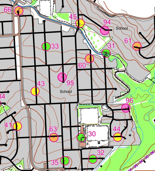
The location of each control is marked on the map by a circle and given a label which is a two digit number. The number of points that a control is worth is given by rounding down the label number to the nearest multiple of 10, (e.g. control 35 is worth 30 points and control 63 is worth 60 points). Also, for clarity, 30 point controls are coloured green, 40 point controls yellow, 60 point controls orange and 90 point controls pink. On the back of the map is a set of “control descriptions”. These descriptions tell what you should see at the control site. For example, the control description for Control 35 might be, “Telegraph Pole JU14077”. Note that you can download the control descriptions from the Newcastle Orienteering club website and print them out if you prefer to have them in a wrist-control-descriptions-holder (so that you don’t have to keep turning the map over to look at them).
In order to determine which controls you have visited we use a smartphone app called MapRun. Basically, you start the app and carry your phone (as well as your map) with you as you go. When you get to a control site your app will beep and put up on the screen the control number you have located. If you have a suitable Garmin watch you can link that with your phone before the event and then go out with just your watch. Click here for more details about using the MapRun app.