


SUNDAY 2 AUGUST
Starts from 9:30am to 11:30am. (Course closure 1PM)
Pre-entries - https://eventor.orienteering.asn.au/Events/Show/10299
There are a few extra Notes at the bottom of this page (updated 5:45pm 30 July 2020).
Map: Rolling Stones, (part of Wallaroo State Forest).
Planning/vetting team: Denis Lyons & Stuart Kurtz.
Control Desciptions are printed on each map. However, if you would like separate descriptions - print them here - WORDS OR SYMBOLS and bring them with you on the day.
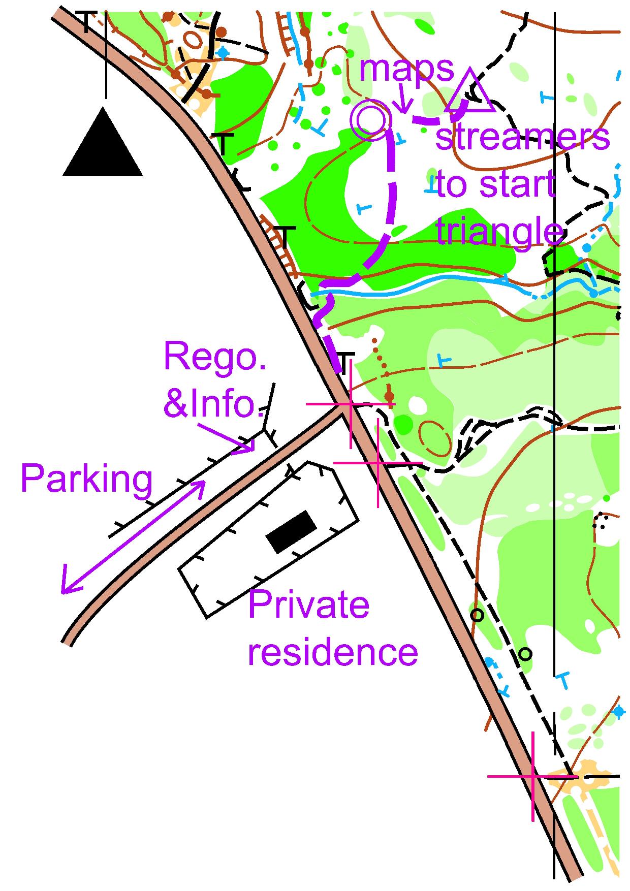
Directions: Head north from Hexham on the highway. Approximately 13.5kms after the Raymond Terrace roundabout turn LEFT onto Italia Rd. (Just after the speed limit changes from 110km/h to 100km/h.)
Follow Italia Rd. for 3km and turn LEFT into Hunter Water’s Balickera Park.
Park inside the park, mainly on the right hand side of the road. Do not block access to a gate. There is a toilet at the Park. (Hopefully it will be open.)
Special Instructions: The courses will take place on the northern side of Italia Rd. TAKE CARE when crossing the road, and follow streamers for 200m to the start/ finish area.
NB. After you start (at start unit) FOLLOW STREAMERS FOR 60m to the position of the START TRIANGLE.
COURSES: All courses will be of NOY standard. (Visit controls in numerical order.)
| Course | Length | Details |
| Very Easy | 1.6kms | Follows tracks and streamer trails. |
| Easy | 1.9kms | Follow tracks, streamer trails and watercourses Controls are not far from tracks, BUT you need to know where you are along the track before looking to the side. |
| Moderate Short | 2.1kms | Cross-country navigation to large features. |
| Moderate Long | 2.6kms | Cross-country navigation to large features. |
| Hard Short | 3.5kms | Some difficult navigation. |
| Hard Medium | 5.5kms | Some difficult navigation. |
| Hard Long | 7.5kms | Some difficult navigation. |
No String Course (due to Covid19 recommendations). Sorry kids. :(
Control Desciptions are printed on each map. However, if you would like separate descriptions - print them here - WORDS OR SYMBOLS and bring them with you on the day.
NOTES:
(1) The area is undulating to hilly. Most of the area is very runnable, however, large areas of water drainage are slow.
The dryness of last summer has caused some smaller trees to die and fall over, causing a “mat” of small trunks.
These areas may look clear from a distance but have been mapped as “slow” or “slow stripe”.
(2) The area is frequented by trail bikes and 4WD’s. If you hear them coming – move out of their way.
(3) SPIKEY vegetation exists to some extent over the area.
(4) Only termite mounds are shown. No tree-root mounds or meat-ant nests. No native cherry trees.
Some large or significant fallen tree canopies have been shown as a thicket of dark green.
(5) At least five helpers are needed to collect Controls at each event. Due to wet tracks - mountain bike or 4WD vehicles would be useful.
Let someone know at the Finish if you can help collect Controls.
(6) Hard Long & Hard Medium change - new track in North West section of the map. Approximate position will be hand drawn on those course maps.