


Bush Foot Orienteering
Pre-register for this Event - click here
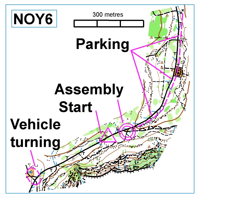
Starts: From 9:30am to 11:30am. (Course closure 1PM). The maps and start units will be at the “start triangle”.
Live Results can be found at sportident.itsdamp.com/directory.php - click here
Directions
From George Booth Drive (B89) turn South-West onto Mt Sugarloaf Road. Continue along this road (it climbs steeply) for 3.0km.
Turn left (South) onto Sugarloaf Range Road. Follow it for approximately 1.3km to the Assembly Area. CAUTION: This road is unsealed and has many potholes!! Speed should be limited to 30kph.
Parking will be limited to the left-hand side ONLY. It may require a 400m walk from the parking to the Assembly Area.
It will be important for competitors to vacate the area as soon as possible after completing their course to free up parking spaces for
later arrivals, and to keep the road clear for access by other road users. Care should be used along this road as 4WD vehicles and motor bikes are common.
To leave the area drivers will need to continue along Sugarloaf Range Road for 300-400m past the Assembly Area where there is a track intersection and space to turn around.
Courses
FULL range of Club NOY courses will be offered.
To download:
WORD Control Descriptions - Click here
SYMBOL Control Descriptions - Click here
While controls are to be visited in numerical order, Hard Long and Hard Medium courses are set with a “MIDDLE DISTANCE” format….this means there are more controls than usual, changes in direction occur, and “pivot” controls set where competitors must visit some controls TWICE during a loop!!
| COURSE | LENGTH | CONTROLS | CLIMB & NOTES |
| VERY EASY | 2.1 km | 13 | 25m. Easier navigation following tracks or taped routes. |
|
EASY |
2.2 km | 11 | 45m Easy navigation and route choices with controls adjacent to tracks. Some taped routes occur. |
|
MODERATE Short |
2.2 km | 10 |
55m Cross-country navigation and route choices with controls on distinct features not far from tracks. |
|
MODERATE Long |
3.8 km | 13 |
95m Cross-country navigation and more difficult route choices. Controls on distinct features. |
| HARD Short | 3.0 km | 12 | 50m Some difficult navigation and route choices. |
| HARD Medium | 4.4 km | 19 | 140m Difficult navigation and physically demanding. |
| HARD Long | 5.4 km | 21 | 235m Difficult navigation and very physical. |
IMPORTANT INFORMATION
- The Sugarloaf Range Road travels through the middle of this map. There are often 4WD and motor bikes travelling at speed. Please TAKE CARE when crossing it or using it for route choice….move out of their way!
- The boundaries of this map to the East and West have high clifflines. These should not be approached as they can be unstable at the top and become slippery. A number of rocky areas and rockfaces occur across the map. Care should be taken in all rock areas, especially if it is wet weather.
- Old barbed wire fences occur on some courses. While these are taped (RED&WHITE) to highlight them, competitors should be cautious near these broken fences.
- “Brown triangles” represent larger “tree-root mounds”. Termite mounds, meat-ant nests and distinctive trees have not been shown. “Black X” represent car wrecks.
- At least five helpers are needed to collect controls following this event. Please let the organisers know if you are available. Thanks for your help.