


Newcastle Orienteer of the Year Event # 8 & Hunter Valley Championships - Stockrington West
Date: Sunday 18 September 2022
Start times: 9:30 am to 11:30 am Course Closure: 1:00 pm
Map: “Stockrington West”. Scale 1:10 000. 5m contour interval. Ian Dempsey 2019.
Course planner: Glenn Burgess.
Directions:
NOTE - The road into the assembly area (Haul Rd) is a closed road that has been opened for the event. It is sealed but narrow in parts and has some potholes and lots of debris. Drive slowly with care. After passing under the expressway and climbing the big hill observe a 30kmh speed limit and BE ALERT FOR RUNNERS ON THE ROAD. All courses cross the road and competitors may choose to run along it. Give way to competitors.
From the East & South - From Seahampton travel northwest on George Booth Drive. After around 5km turn right through a gate into Stockrington SCA. (This turnoff is at the bottom of a hill, 1.3km after the “Welcome to Cessnock” monument). Follow the sealed road carefully for 3.7km to the assembly area.
From the West - Travel south and east on George Booth Drive. About 1km past the Orica turnoff (Echidna Drive) turn left through a gate into Stockrington SCA. Follow the sealed road carefully for 3.7km to the assembly area.
Parking: Drive slowly past the assembly area and park on the side of the sealed road. Use parking space efficiently.
Assembly / Start: The assembly area is adjacent to the road. The start is 30m from the assembly area on the opposite side of the road. After punching the start unit follow the track 30m to the Start Triangle.
COURSE & MAP NOTES (See separate info for Hunter Valley Championships classes - click here)
COURSE LENGTH CLIMB (approx.)
Very Easy 1.4 km 35 m Follows tracks, a watercourse and streamered routes.
Easy 2.1 km 55 m Controls near tracks and watercourses. Some options to cut across.
Moderate Short 2.4 km 70 m Moderate cross country navigation.
Moderate Long 3.5 km 100 m Moderate cross country navigation.
Hard Short 3.4 km 95 m More difficult navigation.
Hard Medium 5.4 km 195 m More difficult navigation.
Hard Long 6.9 km 225 m More difficult navigation.
- All courses cross the sealed road. Orienteering traffic should be the only road users but there may be illegal trial bikes and vehicles on the road or on other trails. Beware of traffic when crossing or running on the road.
- The Very Easy and Easy courses follow taped routes between some controls (not shown on the other courses).
- The Easy and all Moderate and Hard courses cross old fencelines. Beware of wire or cable on the ground which may be a trip hazard.
Terrain: Gently undulating to steep spur/gully eucalypt forest with minor rock detail. Open forest with mostly good running on the ridges and upper slopes. Thicker vegetation in the major gullies. Tree root mounds and thicket detail throughout the map. An old sealed road (closed to public traffic) traverses the western part of the map. Fire trails along the major ridgelines are linked by several trail-bike tracks. Steeper slopes border the area.
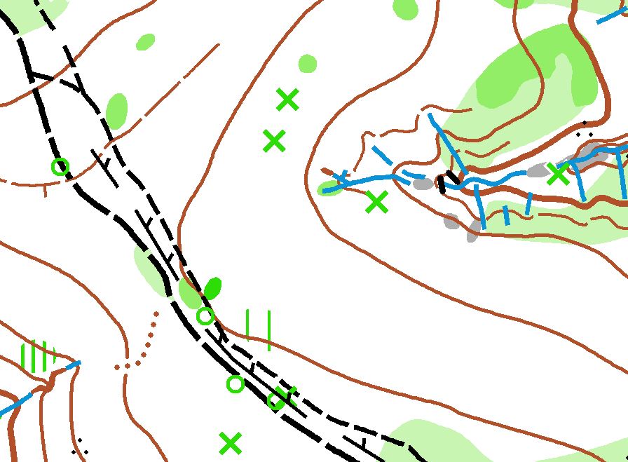
Special map symbols:
Green cross = tree root mound >1.5m
Small green circle = Native Cherry tree(s)
Black circle = man-made feature (eg. metal post, rubbish)
Note - There is extensive tyre debris from illegal burn out activity and other rubbish adjacent to the sealed road, particularly just south of the assembly area. This is not shown on the map.
Control descriptions will be printed on the map and are also available here - WORDS or SYMBOLS.
No water will be provided at the assembly area or on the courses. Please bring/carry your own.
Out of bounds / Warm up area: All forest east of the road and south of the assembly area is out of bounds. Competitors can warm up on the sealed road to the northwest of the assembly/parking.
Safety: The Safety Bearing is WEST to the sealed road, or EAST to the sealed road if you have crossed the road. Beware of traffic when crossing or running on the road.
Help with collecting controls following the event closure will be needed and very much appreciated.