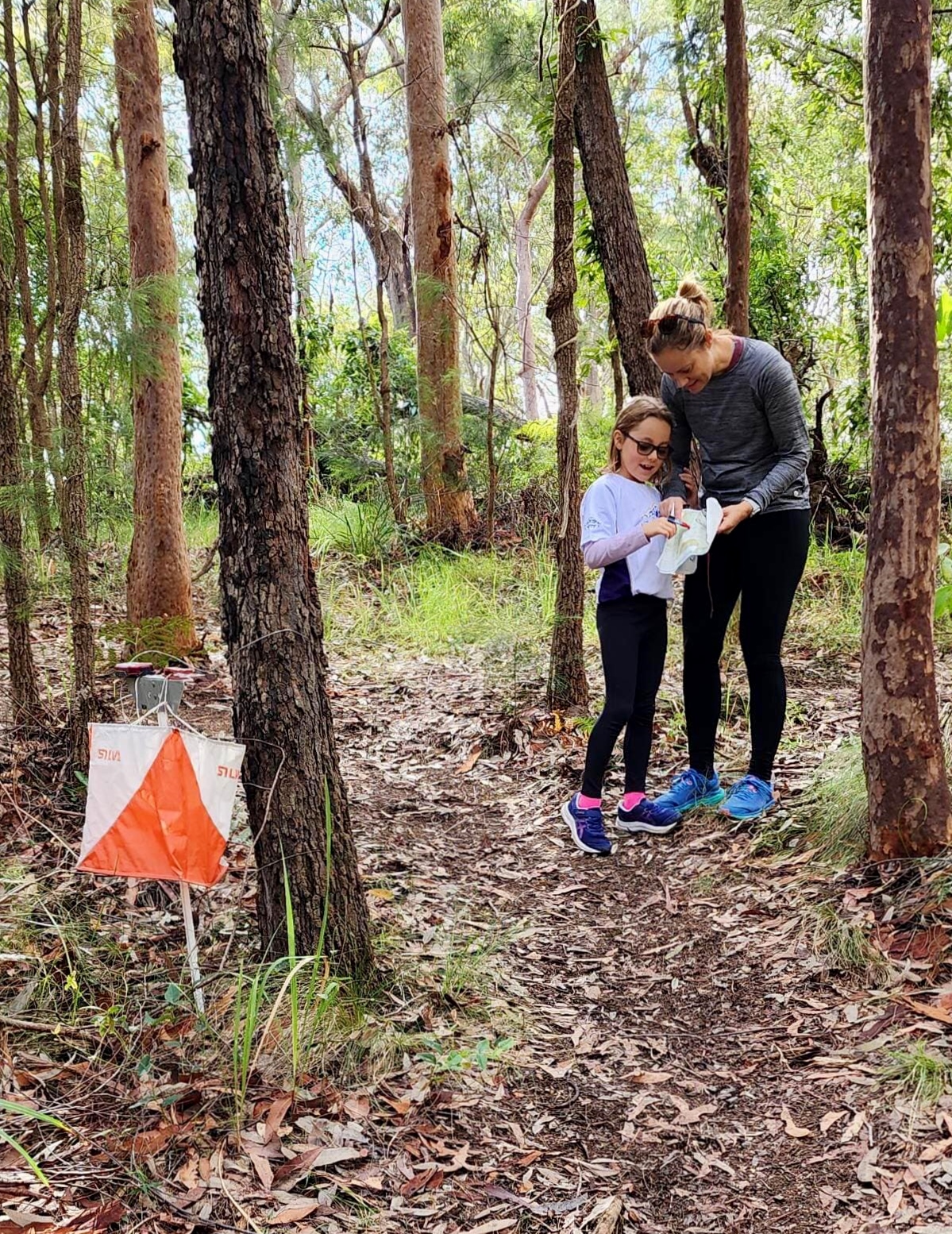
bush
street
urban
mtbo
Run or walk, compete against yourself or others, or just for a family day out. The bush series caters for all in the great outdoors. (April-Nov)
Run, walk or push a pram to a 45 minute time limit. How many points can you get? (Oct-Mar)
Preparation for the Bush. Try out bush style orienteering in local parks before stepping out into the bush. Also includes a night event for the adventurous. (Feb-April)
Grab your mountain bike and ride around bush tracks in either a street style event, bush style event or a combination of the two. (Oct-Mar)

2022Presentations

Click here to Pre-enter.

Click here for more information          RESULTS
______________________________________________________________________________

Hunter Valley Championships 2022

The 2022 Hunter Valley Championships will be held in conjunction with NOY 8 on 18 September 2022.

Available Championships classes are listed in the Age / Course / Class matrix below.

To be official in the Championships results you must enter a class that is an option in the row for your age group (this is the age you are turning in 2022).

You will also be official if you enter a class listed in the same column above your age class. (For example, W60A could instead enter W(50-59)AS or W(19-49)AS).

Open courses can be entered by any age group. AS classes are “Short” classes. AX are “Extra short” classes.

You can enter any course regardless of your age but you will not be official in the Championships results if the course is not an option for your age group.

All results for each course will also be counted in the 2022 Newcastle Orienteer of the Year pointscore.

Hunter Valley Championships - Age / Course / Class matrix

MEN


Age you turn in  2022

Very

Easy

Easy

Moderate Short

Moderate Long

Hard

Short

Hard

Medium

Hard

Long

12 or under

M12A

M14A

M18B

MOpenB

M18A, M19-49AX

M19-49AS

OpenA

13 - 14


M14A

M18B

MOpenB

M18A, M19-49AX

M19-49AS

OpenA

15 - 18


M18B

MOpenB

M18A, M19-49AX

M19-49AS

OpenA

19 - 39


MOpenB

M19-49AX

M19-49AS

OpenA

40 - 49


MOpenB

M19-49AX

M19-49AS

M40A, OpenA

50 - 59


MOpenB

M50-59AS

M50A

M40A, OpenA

60 - 69


MOpenB

M60A

M50A

M40A, OpenA

70 or over


MOpenB

M70A+

M50A

M40A, OpenA


WOMEN


Age you turn in  2022

Very Easy

Easy

Moderate Short

Moderate Long

Hard Short

Hard Medium

Hard Long

12 or under

W12A

W14A

W18B

WOpenB

W18A, W19-49AS

WOpenA

OpenA

13 - 14


W14A

W18B

WOpenB

W18A, W19-49AS

WOpenA

OpenA

15 - 18


W18B

WOpenB

W18A, W19-49AS

WOpenA

OpenA

19 - 39


WOpenB

W19-49AS

WOpenA

OpenA

40 - 49


WOpenB

W19-49AS

W40A, WOpenA

OpenA

50 - 59


WOpenB

W50-59AS

W50A, WOpenA

OpenA

60 - 69


WOpenB

W60A

W50A, WOpenA

OpenA

70 or over


WOpenB

W70A+

W50A, WOpenA

OpenA

Newcastle Orienteer of the Year Event # 8 & Hunter Valley Championships - Stockrington West

Date: Sunday 18 September 2022

Start times: 9:30 am to 11:30 am     Course Closure: 1:00 pm

Map: “Stockrington West”. Scale 1:10 000. 5m contour interval. Ian Dempsey 2019.

Course planner: Glenn Burgess.

Directions:

NOTE - The road into the assembly area (Haul Rd) is a closed road that has been opened for the event. It is sealed but narrow in parts and has some potholes and lots of debris. Drive slowly with care. After passing under the expressway and climbing the big hill observe a 30kmh speed limit and BE ALERT FOR RUNNERS ON THE ROAD. All courses cross the road and competitors may choose to run along it. Give way to competitors.

From the East & South - From Seahampton travel northwest on George Booth Drive. After around 5km turn right through a gate into Stockrington SCA. (This turnoff is at the bottom of a hill, 1.3km after the “Welcome to Cessnock” monument). Follow the sealed road carefully for 3.7km to the assembly area.

From the West - Travel south and east on George Booth Drive. About 1km past the Orica turnoff (Echidna Drive) turn left through a gate into Stockrington SCA. Follow the sealed road carefully for 3.7km to the assembly area.

Parking: Drive slowly past the assembly area and park on the side of the sealed road. Use parking space efficiently.

Assembly / Start: The assembly area is adjacent to the road. The start is 30m from the assembly area on the opposite side of the road. After punching the start unit follow the track 30m to the Start Triangle.

COURSE & MAP NOTES (See separate info for Hunter Valley Championships classes - click here)

COURSE           LENGTH    CLIMB (approx.)

Very Easy            1.4 km         35 m                Follows tracks, a watercourse and streamered routes.

Easy                    2.1 km         55 m                Controls near tracks and watercourses. Some options to cut across.

Moderate Short    2.4 km         70 m                Moderate cross country navigation.

Moderate Long     3.5 km         100 m             Moderate cross country navigation.

Hard Short           3.4 km         95 m                More difficult navigation.

Hard Medium       5.4 km         195 m              More difficult navigation.

Hard Long           6.9 km         225 m              More difficult navigation.

- All courses cross the sealed road. Orienteering traffic should be the only road users but there may be illegal trial bikes and vehicles on the road or on other trails. Beware of traffic when crossing or running on the road.

- The Very Easy and Easy courses follow taped routes between some controls (not shown on the other courses).

- The Easy and all Moderate and Hard courses cross old fencelines. Beware of wire or cable on the ground which may be a trip hazard.

Terrain: Gently undulating to steep spur/gully eucalypt forest with minor rock detail. Open forest with mostly good running on the ridges and upper slopes. Thicker vegetation in the major gullies. Tree root mounds and thicket detail throughout the map. An old sealed road (closed to public traffic) traverses the western part of the map. Fire trails along the major ridgelines are linked by several trail-bike tracks. Steeper slopes border the area.

NOY8 Stockrington map snippet

Special map symbols:

Green cross = tree root mound >1.5m

Small green circle = Native Cherry tree(s)

Black circle = man-made feature (eg. metal post, rubbish)

Note - There is extensive tyre debris from illegal burn out activity and other rubbish adjacent to the sealed road, particularly just south of the assembly area. This is not shown on the map.

Control descriptions will be printed on the map and are also available here - WORDS or SYMBOLS.

No water will be provided at the assembly area or on the courses. Please bring/carry your own.

Out of bounds / Warm up area: All forest east of the road and south of the assembly area is out of bounds. Competitors can warm up on the sealed road to the northwest of the assembly/parking.

Safety: The Safety Bearing is WEST to the sealed road, or EAST to the sealed road if you have crossed the road. Beware of traffic when crossing or running on the road.

Help with collecting controls following the event closure will be needed and very much appreciated.

NOY8

HV Champs RESULTS - Click here    NOY8 RESULTS - Click here        Click here for more information   Click here for HV Championship dretails

bush   NOY7 - Sugarloaf North                              

      28 Aug 2022


MtSugarloaf

 Click here for more details. Click here to Pre-Enter.     RESULTS
______________________________________________________________________________________________________

  Peter Newton Brief

 Click here for more details. Click here to Pre-Enter.     RESULTS
______________________________________________________________________________________________________

Date: Sunday 17th July 2022

Starts:  9:30-11:30 am    Course Closure 1 pm

Map: Redgum Ridges 1:10 000

Assembly: 150m inside and east of the main gate.  GPS: -32.98862, 151.50169

PLEASE CAR POOL DUE TO LIMITED PARKING  (see important information below)

Directions 

From M1 take the Toronto Exit (Palmers Rd) then head west twowards Freeman’s Waterhole. From Cessnock travel to Freemans Waterhole and turn left at the roundabout heading towards Toronto. The event is on the sounthern side 1.5km along Palmer’s Rd.

Give plently of indication when turning. It is a 90km per hour road.

Parking: Due to recent wet weather, there will be limited parking at the assembly and in the areas previously used west of the main gate. (15-20 cars). Some off road parking is located 1km west of the freeway junction (150m after the private road, and immediately after you cross the concrete bridge on the road). Turn left into a small parking area which may hold approximately 20-40 cars depending on weather. It is a 500m walk west to the assembly. Once full, vehicles will need to park on the southern side of the main road (Palmers Rd) well before, and well after the main gate. Park as far off the edge of the main road as possible and take extra care when opening doors. Please keep away from the main gate entrance as our landholders have requested access.

Another possiblity is to park at Freemans Waterhole, 1.5 kms west, and use it as your warm up and cool down run, or arrange to car pool from the Lake Maquarie Memorial Park at Ryhope (just east of the Freeway junction) where there is plenty of parking. Thank you for your help.

Parking layout

Courses: The start for all courses will be 50m east of the registration.

Hard Long - 6.4km, 200m climb, 19 controls  (includes a spectator control before a final hill loop)

Hard Medium - 4.9km, 160m climb, 16 controls

Hard Short - 3.5km, 115m climb, 12 controls

Moderate Long - 4.0km, 85m climb, 15 controls

Moderate Short - 2.5km, 65m climb, 11 controls

Easy - 2.5km. 60m climb, 10 controls

Very Easy - 2.1km, 55m climb, 11 controls

Control Descriptions are printed on the maps. If you'd like to have an additional copy - download them here -  words or symbols

Fees

Notes 

  • The Redgum Ridges map features intricate detail in watercourses and lower slopes, separated by steep ridges. Tracks are mostly restricted to the ridge lines. The bush is mostly open and very runnable in most parts.
  • Some watercourses are deeply eroded with steep to vertical sides. These can be difficult to cross and be slippery.
  • Derelict barbed wire fences parallel many of the tracks - some are marked with red tape.
  • If heavy rain precedes the event some creeks may be difficult to cross.
  • Leg protection is recommended.
  • Some leeches have been found during setting and vetting.
  • Trail bikes are active and there is an acess road through the course to a neighbours house (south from the main gate ) that most runners will cross or use during their course. Keep out of their way.
  • Tree root mound symbol has been removed from this map. X = wreckage; O = survey post
  • One streamer trail is shown on the relevant maps with pink/ purple dashes.
  • No toilets at the event. Nearest at Freemans Waterhole.

Saftey Bearing: North to the main track

Acknowledgements: Thanks to State Forests and adjacent landholders the Sheedy and Cleary families for allowing us access. Thanks to Jenny and Erika Enderby for vetting the course.

At least 3 helpers are needed for parking, and 5 helpers are needed to collect controls.

 PortMacqInfo

For more details - click here

WauchopeInfo

For more details - click here


PortMacqnWauchope2022


  For those who have entered
   these Events
   (entries closed last Friday).

  Saturday 9 July 2022 &
   Sunday 10 July 2022

  For more information - Click here


“Contours and Compass” Training

Description:
The area is on the outskirts of Newcastle and is characterised by an intricate track network, complex water features, a major powerline, and mixed runnability. Like many areas, there are some features that are more liable to change over time (e.g., tracks, car wrecks, vegetation) than others (e.g., contours, rocks, major water features). The purpose of this training event is to practise using the reliable features to help navigate around the course, even when utilising the tracks!
Courses:
Easy, 2.1 km – Controls are on or close to tracks. Practise checking direction with your compass, and the shape of the land using the contours, rather than just relying on the tracks themselves.
Moderate, 3.4 km – Longer legs and harder control sites than Easy. Structure each leg carefully and make sure you have a clear attack point.
Hard Short, 3.6 km – Full difficulty and some low visibility areas. To sharpen focus on navigating by more reliable features (and compass), tracks have been removed from the map. Power pylons are also gone. A blank complete map is on the flip side, however, as a backup.
Hard Long, 5.8 km – Like Hard Short but with a map flip halfway and no blank complete map as backup. Some controls are in the greener areas in the north not visited by the other courses.
Each control is marked by a flag and an electronic (SportIdent) punching unit.

Control Descriptions:
WORDS or SYMBOLS

The start for all courses is 200 m from the assembly area. Follow the blue and white streamers.

Starts are from 9.30 – 11.30 am. Course closure at 1 pm.

Directions:
Head to Killingworth. In Killingworth turn north onto The Boulevarde that becomes Killingworth Rd. After about 1 km park carefully along the side of the road near the Transgrid substation. Note that there are numerous potholes on Killingworth Rd – drive slowly!

Safety:
The area is frequented by motorbikes and 4WDs. Give them a wide berth!
Safety bearing is south-east to Killingworth Rd and then back to the assembly area near the substation.

Planner:
Stephen Craig, 0447 166 281

Date Sunday 26th June 2022

Starts  9:30-11:30 am     Course Closure 1 pm

Map The Powerlines 1:10 000

Assembly Just North of the junction of Goulburn and Lismore Streets, Abermain. Follow a short trail from the street junction.

Directions From Freemans Drive

Continue from Freemans Drive on Leggetts Drive, turn left onto Lake Rd to Kearsley then continue straight on Allandale Rd which turns into Neath Rd. Follow Neath Rd to the end and turn right on Cessnock Rd. Turn left onto Goulburn St, Abermain and follow to the end (Lismore Street). 

From Hunter Expressway

Take the Hart Rd exit and turn South west onto Hart Rd. Continue on Gingers Lane then turn left on Frame Dr. Turn right onto Lismore St, Abermain and follow until the junction of Goulburn St.

Parking Park along the bush side of Lismore St (nose in if there is space) preferably. You can also park further along Lismore St and Goulburn St. Avoid the fenced council works area.

Courses: The start for all courses will be 100m north of the registration. The finish for all courses will be 100m North West of the assembly area/registration. No toilets available near the start.

                   Hard Long - 6.9km, 80m climb, 20 controls

                   Hard Medium - 5.2km, 70m climb, 17 controls

                   Hard Short - 3.4km, 50m climb, 13 controls

                   Moderate Long - 3.4km, 50m climb, 15 controls

                   Moderate Short - 2.6km, 40m climb, 18 controls

                   Easy - 2.2km. 25m climb, 16 controls

                   Very Easy - 2.1km, 25m climb, 15 controls

Control Descriptions are printed on the maps.  If you'd like to have an additional copy - download them here -  words or symbols

Notes (a) The area has an extensive track network. Some low areas are wet and muddy though most tracks are dry except in a few places. There are some large erosion gullies with fallen trees at the edges so take care in those areas. There is some rubbish on the map which includes rusty corrugated iron, household appliances and car wrecks. The old rubbish tip is marked as Out Of Bounds and marked on the map with pink hatched lines - do not enter or cross this area (only Long Moderate and Hard courses go near this area). Very Easy and Easy Courses follow a dry watercourse for a short way.

(b) TRAIL BIKES and 4WD’s use the area. KEEP OUT OF THEIR WAY.

(c)  The area does contain SPIKEY VEGETATION. Hard courses (mostly Hard Medium and Long) may wish to have full body cover (long pants and long sleeves).

(d) 1. Brown triangle represents small termite mounds.  Meat- ant nests are NOT SHOWN.

  1. Prominent tree-root mounds are shown with a green X.  There may be new unmapped tree root mounds due to a strong recent wind storm knocking over several large trees.
  2. Streamer trails are shown on relevant maps with pink/ purple dashes.

(e) At least 5 helpers are needed to collect controls at every event.

Date: Sunday 19 June 2022

Starts: 9:30 - 11:30 am Course Close 1:00 pm

Map: Blue Gum Hills (central section) 1:7500 5m contours

Format: This will be a mixed format event with the emphasis on gaining knowledge from
more proficient orienteers by optionally having a “coach” accompany you on
course. They can either demonstrate the basics from map orientation and
interpretation through to route planning or alternately assist with any navigational
weak point you may have. This is aimed at both the newer orienteer and those that
may have been orienteering for some time but are still having some difficulties.
Additionally, the course planner will be available prior to your “run” to discuss your
course selection, proposed route and the terrain you will encounter and also again
post “run” to go over your course. Please contact the organiser to pre-register
your interest in either having or being a “coach” for this event.

Directions: Travel to Blue Gum Hills Regional Park Minmi. Pass through the main entrance.
Continue to the roundabout beyond the carpark where you will be directed through
a gate. From this point it is 800m to the assembly on a good gravel road, but it does
have drainage humps that may be difficult for low or long wheel based vehicles to
cross. Alternately park at the carpark and walk via the Heritage Trail or cycle in.

Courses:

Very Easy Select this basic orienteering course which follows
tracks (or taped routes) if you are a novice or younger junior.
 1.4 km  9 controls


Easy

Slightly harder than Very Easy - great for adult novices. 1.3 km 8 controls


Progressive

Select this if you are wanting to step up from
Easy to Moderate courses or confident adult novice.
Begins Very Easy and progresses to Moderate navigation
on last few controls.
1.7 km 8 controls


Score Course

Choose your own adventure by visiting as many
controls as you want in any order. Mostly Moderate level
navigation with a few harder point features.
3.2 km (est) 16 controls

 
Punching SI Units will be set to beacon mode but will not be turned on until the first person
inserts their SI stick.

Controls/flags will be a mixture of stands and hanging type.

Notes: Some minor tracks in the western part of the map are now less defined and marked
with blue/white tapes. Optional crossing points are indicated by blue/white tapes.

Safety: Full leggings are advised. Rolling under fences is the safest method of crossing.
Known mining subsidence is marked on map with pink dots but unmarked in field.

Cost: $6 with free entry to first timers.

Entries: Pre-entry preferred but there will be enter on day available. Click here

First-timers how to register & enter for free Click here

Water: Please supply all your own needs including on-course hydration.

Facilities: There are toilets, BBQs and a maze in the main park on the way in/out.

Contact: Geoff Peel 0422 471 353 This email address is being protected from spambots. You need JavaScript enabled to view it.


bush


           Bush Series 2022 Calendar.

 Date  Event  Location  Information   Results     
20/03/2022 SL2  Honeyeater Hideout Click here Eventor    
03/04/2022  NOY1  Hebburn Road Click here Eventor    
01/05/2022  NOY2  Fairley Dams Click here Eventor    
 08/05/2022  Pairs  Jesmond Park Click here Eventor    
22/05/2022 Minor  Jigadee Click here Eventor    
29/05/2022  NOY3  Mining Mystery Click here Eventor    
05/06/2022 Training  Heart Rate Hills Click here      
19/06/2022 Training  Blue Gums Hills Click here Eventor    
26/06/2022  NOY4   Abermain Click here Eventor    
03/07/2022 Training The Range - West Wallsend  Click here Eventor    
17/07/2022  NOY5  Redgum Ridges Click here Eventor    
24/07/2022 Training  Wallaroo Click here      
31/07/2022 Training  Rathmines Click here      
07/08/2022 NOY6  Stockrington West Click here Eventor    
09/08/2022  Hunter Schools   The Range Click here      
28/08/2022 NOY7  Sugarloaf North Click here Eventor    
18/09/2022 NOY8/HVC  Stockrington West Click here Eventor    

  Newcastle Orienteer of the Year (NOY) Series Standings - click here 

    Click here to learn more about Orienteering

Date Sunday 29th May Starts  9:30-11:30 am     Course Closure 1 pm

Map Mining Mystery 1:7 500

Assembly Hebburn St, Pelaw Main. Assembly will near the railway station on the left after passing through the gate.

Directions From John Renshaw Drive

Turn left onto Railway St Kurri Kurri at the roundabout after passing McDonalds then after 350m turn left onto Stanford St. After 500m turn right onto Hebburn St and proceed for 500m through the gate. Parking and assembly will be on the left.

From Leggetts Drive

Turn left onto Hebburn St Pelaw Main and proceed for 500m through the gate. Parking and assembly will be on the left.

Courses: The start for all courses will be 150m W. of the registration. The Hard Long course will have a streamer trail leading away from the start.     

                   Hard Long - 7.2km, 100m climb, 20c

                   Hard Medium - 5.3km, 70m climb, 14c

                   Hard Short - 3.3km, 50m climb, 10c

                   Moderate Long - 3.1km, 40m climb, 12c

                   Moderate Short - 2.1km, 20m climb, 10c

                   Easy - 1.8km. 20m climb, 13c

                   Very Easy - 1.6km, 10m climb, 11c

Control Descriptions are printed on the maps.  If you'd like to have an additional copy - download them here -  words or symbols

Notes (a) The area has an extensive track network. Low areas are very wet and muddy. There has been vegetation regrowth over most of the map with some heavily vegetated areas.

(b) TRAIL BIKES and 4WD’s use the area. KEEP OUT OF THEIR WAY.

(c)  The area does contain SPIKEY VEGETATION.

(d) 1. Brown triangle represents small termite mounds.

  1. Prominent tree-root mounds are shown with a green X. Meat- ant nests are NOT SHOWN.
  2. Streamer trails are shown on relevant maps with pink/ purple dashes.

(e) At least 5 helpers are needed to collect controls at every event.


NEW INFORMATION:
There will be toilet facilities available.
There are large pieces of machinery around the assembly area.  Please keep clear and keep children from climbing on them.
There is an area of mine subsidence marked with red and white tape in the field. Please avoid this area.

2022 Newcastle Orienteering of the Year - Event 2 - O’Donnelltown

 Date Sunday 1st May Starts  9:30-11:30 am 

 Map Fairley Dams 1:10 000

 Assembly O'Donnelltown Rd, 300m past the overpass over the M1 Motorway. Parking on both sides of O'Donnelltown Rd.

 Directions From the M1 Motorway Northbound

Take the George Booth Drive exit and turn right. At the next roundabout, turn right onto Carrington St and proceed through West Wallsend onto Railway St. Turn right onto O'Donnelltown Rd and proceed for 1km to the Overpass over the M1. The assembly area and parking are a further 300m ahead to the left.

From the M1 Motorway Southbound

Take the Newcastle exit onto Newcastle Link Rd. Turn right at the lights onto Cameron Park Drive and proceed 2km to the roundabout at George Booth Drive. Continue straight ahead onto Carrington St and proceed as above.

 Courses     Hard Long - 6.9km, 220m climb, 21c

                   Hard Medium - 5.2km, 160m climb, 19c

                   Hard Short - 3.8km, 120m climb, 12c

                   Moderate Long - 3.6km, 75m climb, 11c

                   Moderate Short - 2.6km, 60m climb, 8c

                   Easy - 2.2km. 60m climb, 9c

                   Very Easy - 1.8km, 40m climb, 10c

Control Descriptions are printed on the maps.  If you'd like to have an additional copy - download them here - WORDS or SYMBOLS.

 Notes Generally Open runnable forest with some denser vegetation around the main creek system adjacent to the assembly. Terrain is undulating with steeper sections including some cliff lines and rock detail for the Hard Courses on the side of one of the major spurs off Sugarloaf Range. There has been substantial regrowth of vegetation on the upper slopes of the map which limits visibility in some areas. The area is very wet and muddy generally from the extended periods of rain in the last few months. Full body cover recommended and be sure to check for leeches!

Uncertain about whether this course snippet is at the easy, very easy, moderate or hard standard?

Moderate

 Go to the Resources page and follow the link from Event Specific Documents: Bush Series

  2022 Newcastle Orienteer of the Year (NOY) Series Standings - click here

  2022 Calendar - click here


Sunday  April 3 (2022)          9:30am to 11:30am      Course Closure  1PM

Map:        “HEBBURN ROAD”    1: 10 000   5M contours

Planning. Denis Lyons.     Vetting. Bob and Pam Montgomery.

The area is of Werakata NP. Which straddles the flatter (Southern) end of Hebburn Rd. There are no large hills, but a number of areas of thick ti-trees will add to your route choices.

DIRECTIONS: From the junction of Leggetts Drive and Lake Rd. travel on Lake Rd. for 4.8KM to turn right onto Hebburn Rd. (GRAVEL road –SPEED HUMP and CAMERA). 

                            From Kearsley, follow Lake Rd. (to the east) for 3KM to turn left onto Hebburn Rd.

                             The registration area will be (Approx) 730m from the turn off.

Parking: DO NOT PARK IN THE FIRST 720M FROM THE TURN OFF. “Runners will be crossing.”

                                                                                                                               TAKE CARE!                                         

                    Most parking can be found in mowed areas on the eastern side of the road, immediately north of the assembly point. Mostly park at right-angles to the road. Some spots may need angle or parallel parking. Further on, use the western side of the road. MAKE SURE TO LEAVE ROOM FOR TWO-WAY TRAFFIC. Don’t block trail bike tracks. (A number of vehicles access the old mine site on some Sundays. Also a large refrigerated van may need access.)

COURSES: Courses will be mostly on the western side of Hebburn Rd. The three HARD courses will cross to the eastern side of the road, and have a separate FINISH on the eastern side, near the registration area. The Finish for the HARD courses will be marked with an Orienteering flag rather than a Finish banner.

The start for all courses will be 70m NW. of the registration. Follow signs.

The start triangle will be at a bend in one of the trail bike tracks. IF YOU HEAR BIKES IN THE AREA, IT MAYBE WISE TO DELAY YOUR START UNTIL THEY HAVE MOVED AWAY.

Course                                length     climb                             

VERY EASY.                  1.8 KM      35m Follows tracks and streamer trails.

EASY.                            2.1 KM       40m Controls near tracks or streamer trails. You need to be able to recognise, and possibly follow, a watercourse.

MODERATE SHORT.   2.1 KM       40m        Moderate cross-country navigation

MODERATE LONG.     3.0 KM        50m                            “

HARD SHORT.              3.5 KM       50m                                Difficult navigation

HARD MEDIUM.          5.2 KM       70m                                            “

HARD LONG.                7.1 KM       95m                                            “

 Notes

(a) The start TRIANGLE will be at a track bend, approximately 20m in front of the START UNIT.

(b) TRAIL BIKES and 4WD’s use the area. KEEP OUT OF THEIR WAY.

(c)  The area does contain SPIKEY VEGETATION.

(d) 1. Brown triangle represents small termite mounds.

     2. Prominent tree-root mounds are shown with a green X. Meat- ant nests are NOT SHOWN.

     3. Streamer trails are shown on all maps with pink/ purple dashes.

(e) At least 5 helpers are needed to collect controls at every event.

Bush Event Entry Fees:

    Adults   Juniors   Family
  Members   $14   $10   $38
  Non Members   $17   $12  
First Timers FREE Inc Stick Hire  

*Family - Two Adults and two children (or more children)

Second map $5

SportIdent stick hire $2

Your Event Entry Fee Destination 2


member

renew

NOCLogo

INTRO

permanentcourse

Facebook1